EXPLORE THE OPPORTUNITIES

CONSERVATION

The Reserve finalized its first comprehensive upland habitat map in 2010 and is currently putting together a new updated map that will allow staff to identify areas of change. Identifying habitat change can provide crucial insights into the causes of change as related to sea level rise and extreme weather events such as hurricane and wildfire. Also, in 2015 RBNERR finalized its very first comprehensive benthic map for the entire Reserve. We will be seeking funding to update this current benthic map in 2020.

Possible causes of any habitat change will be studied. The Reserve used aerial imagery of the entire Reserve and field surveys of a portion of the Reserve to determine the types of habitats present. Monitoring equipment will be installed to measure changes in sea level, tides, sediment level, and ground water and soil characteristics. In addition, vegetation monitoring will be conducted annually at select sites.

INVASIVE SPECIES MONITORING, CONTROL AND ERADICATION

INVASIVE SPECIES MONITORING, CONTROL AND ERADICATION

Non-native, invasive plants and animals threaten Florida’s beautiful native wildlife. Species not found in Florida prior to the arrival of the first European settlers are considered non-native or exotic, and these species can become invasive when they defeat native species in the life-long competition for food, sunlight, and space.

The problem often comes from plants, insects, fish, as well as reptiles and many of the species are being discovered here every day. These flying, swimming, and slithering invaders have either arrived accidentally, have escaped captivity, or have been freed by their former owners who have become unable or unwilling to care for them any longer.

The environmental impacts of many recent arrivals have not been fully realized, and scientists are trying to learn about these species before their presence here creates problems beyond repair. Some of the most problematic species affecting the reserve include Brazilian pepper, feral pig, and pythons.

Invasive plants grow quickly, spread rapidly, and often displace native plants. When native plants get crowded out, the area can become a “monoculture” which is unsuitable habitat for wildlife. In general, invasive vegetation provides a habitat with inadequate shelter and insubstantial nutrient value for native wildlife.

The state of Florida spends millions of dollars annually on invasive species control. The figures are staggering and invasive species require constant maintenance so that they do not squelch the native species. According to the 2011-2012 Aquatic Plant Management report from FWC, “Invasive plants infest 94% of Florida’s 438 public waters inventoried in 2012 that comprise 1.26 million acres of fresh water.

Rookery Bay NERR is a strong partner in the Southwest Florida Cooperative Invasive Species Management Area (C.I.S.M.A.) organization.

The mission of the Southwest Florida CISMA is to coordinate and increase efforts between local, state and federal agencies and landowners of all sizes. The goal is to reduce the impact of or eliminate invasive, non-native plants and non-native animals by combining programs and resources to address invasive species on a landscape level to achieve common goals and objectives. Education and outreach will play a vital role in securing cooperation with public lands, private landowners, homeowners and visitors to the region. This group was founded in September 2008 after a long history of cooperative efforts on public and private lands in this region with many efforts that spilled over onto private lands.

Visit their website by clicking here. 

CULTURAL RESOURCE MANAGEMENT

CULTURAL RESOURCE MANAGEMENT

Reserve staff document and protect cultural resources, including prehistoric and historic artifacts and settlement sites. A new GIS-based cultural resource database has been created for all data related to the Reserve’s cultural sites. This database will allow for easier updating of data and for easier access for researchers needing information. In order to assess, interpret and protect the vast range of cultural resources on Reserve lands, staff will continue to initiate, facilitate or conduct targeted research. Research examples include the recent survey of the northern half of the reserve and the new database creation. Updated data will serve as the basis for developing a comprehensive cultural resources management plan.

Check out the second floor exhibits and the Snail Trail at the Environmental Learning Center.

HABITAT MAPPING CHANGE

HABITAT MAPPING CHANGE

The Reserve finalized its first comprehensive upland habitat map in 2010 and is currently putting together a new updated map that will allow staff to identify areas of change. Identifying habitat change can provide crucial insights into the causes of change as related to sea level rise and extreme weather events such as hurricane and wildfire. Also, in 2015 RBNERR finalized its very first comprehensive benthic map for the entire Reserve. We will be seeking funding to update this current benthic map in 2020.

Possible causes of any habitat change will be studied. The Reserve used aerial imagery of the entire Reserve and field surveys of a portion of the Reserve to determine the types of habitats present. Monitoring equipment will be installed to measure changes in sea level, tides, sediment level, and ground water and soil characteristics. In addition, vegetation monitoring will be conducted annually at select sites.

MARINE MAMMAL STRANDING NETWORK

MARINE MAMMAL STRANDING NETWORK

Many members of the Rookery Bay staff are active, trained participants in the Marine Mammal Stranding Network – Southeast region. Members of this network provide response assistance as needed by the Florida Fish and Wildlife Conservation Commission (FWC) and the Florida Wildlife Research Institute, which are the lead agencies on sea turtles, manatees, dolphins and whales in Florida waters.

In response to a call for help from the waters in or around the Rookery Bay Reserve, FWC contacts staff at Rookery Bay to verify the report (floating objects are sometimes misidentified), the precise location, and the nature of the injury or perceived illness. They often stay with the animal until more help is able to arrive on the scene, assist with or provide transportation to Miami Seaquarium or Lowery Park Zoo for rehabilitation, and are sometimes even on-hand to assist with the animal’s subsequent release back into the same waters from where it was rescued. To report a marine mammal in distress, call the Marine Mammal Stranding hotline at 888-404-FWCC (3922).

The “Dolphin & Whale 911” app (for both Apple and Android users) enables the public in the Southeast U.S. to immediately report live or dead stranded, injured, or entangled marine mammals by connecting them to the nearest stranding response hotline. The “SEE & ID Dolphins & Whales” app (for both Apple and Android users) is an electronic field guide that assists the public in identifying marine mammals in the Southeast U.S. and provide species information, such as physical description, biology, habitat, conservation/status and photos. The app also informs that public of appropriate ways to enjoy viewing marine mammals in the wild without harming or harassing them.

PANTHER RANGE EXPANSION

PANTHER RANGE EXPANSION

The Reserve finalized its first comprehensive upland habitat map in 2010 and is currently putting together a new updated map that will allow staff to identify areas of change. Identifying habitat change can provide crucial insights into the causes of change as related to sea level rise and extreme weather events such as hurricane and wildfire. Also, in 2015 RBNERR finalized its very first comprehensive benthic map for the entire Reserve. We will be seeking funding to update this current benthic map in 2020.

Possible causes of any habitat change will be studied. The Reserve used aerial imagery of the entire Reserve and field surveys of a portion of the Reserve to determine the types of habitats present. Monitoring equipment will be installed to measure changes in sea level, tides, sediment level, and ground water and soil characteristics. In addition, vegetation monitoring will be conducted annually at select sites.

As part of their listed species monitoring program, Rookery Bay Research Reserve biologists use wildlife cameras at a known crocodile nesting site to document nesting and predation. Over the past few years, staff has been assisting FWC biologists piece together clues about the panther population and have turned to technology to learn more about uncollared panthers.

Wildlife cameras installed in a number of locations including those previously suspected travel corridors are recording a more consistent presence of uncollared cats in this coastal area. The image resolution is even good enough to identify individual cats. The camera also records time and date of every visit, enabling biologists to not only confirm these coastal areas are important habitat, but to learn more about their overall health and other details not previously available through tracking data alone. The cameras provide a rare opportunity to observe endangered species behavior. The panther in the video below was clearly curious about the camera however, as it stayed in view for nearly 30 minutes.

LISTED SPECIES MONITORING AND CONSERVATION

LISTED SPECIES MONITORING AND CONSERVATION

Rookery Bay is home to over seventy threatened and endangered species, ranging from the tiny sand dune spurge to the hefty American crocodile. Reserve staff actively monitor listed plants and animals, and keep a working list of rare species found within Reserve boundaries. The Reserve is actively partnering with the Naples Botanical Garden to monitor and manage several of our listed plant species and to search for new listed species within Reserve boundaries. Together with FWC, the Conservancy of Southwest Florida, and other partners, we monitor sea turtles, shorebirds, marine mammals, and panthers. Rookery Bay is committed to protecting and monitoring listed species within the Reserve.

PRESCRIBED FIRE

PRESCRIBED FIRE

Fire is a process of rejuvenation. Some benefits of fire include replenishing nutrients in the soil, reducing natural fuel loads (downed limbs and dead leaves), stimulation of seed production, and maintenance of natural plant communities that benefit native wildlife. Although plants look pretty scorched after a fire, they resprout in a matter of weeks. Even during this time of blackness, beauty is everywhere, and wildlife is taking advantage of newly-available food resources.

TEAM OCEAN

TEAM OCEAN

  • Ocean
  • Conservation
  • Education
  • Action
  • Network

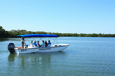
Team OCEAN is a highly trained and dedicated group of volunteers with a main mission of outreach and education. For many visitors, the only chance to learn about the local environment and the reserve itself is through these volunteers. Most of their activity is boat based, allow them to interact with people in many different areas of the reserve including the ecologically diverse and important barrier islands. In 2019 Team OCEAN members recorded over 9,000 visitor contacts and 6,000 hours of volunteer work.
In 2017 their efforts were rewarded with Audubon of Florida’s prestigious Guy Bradly Award.

MAKE A DIFFERENCE

Become a Friend of Rookery Bay

Support this amazing and important ecosystem today and know that your impact will be felt for generations to come.

VOLUNTEER

Take a hands-on approach to supporting our efforts.

DONATE

Your donation will positively impact our coastal treasure, Rookery Bay Research Research.

MEMBERSHIP

Join our family - become a member and take advantage of of membership perks and privileges.